
-
Visit DualSportBC Facebook group with over 10 000 active members: https://www.facebook.com/groups/dualsportbc
- Home
- Forums
- Forum
- HISTORICAL DOCUMENTS (The Archives)
- Regional Area Forums of BC CLOSED
- The Kootenay / Boundary Region
- Kootenay DSBC Riders Section
You are using an out of date browser. It may not display this or other websites correctly.
You should upgrade or use an alternative browser.
You should upgrade or use an alternative browser.
Sandon to Retallack GPS track?
- Thread starter aebbern
- Start date
imported post
imported post
Okay - think I found it.
I used this site: http://aardvark.gov.bc.ca/apps/recst/html/recsites_base_map.htm
Zooming in to the Sandon area I came across this lovely series of switchbacks running out of Cody up and over the mountain and descending into Retallack... looks nice!

imported post
Okay - think I found it.
I used this site: http://aardvark.gov.bc.ca/apps/recst/html/recsites_base_map.htm
Zooming in to the Sandon area I came across this lovely series of switchbacks running out of Cody up and over the mountain and descending into Retallack... looks nice!

250ccforme
Member
imported post
imported post
Did Retallack to Sandon via Rico on a mountain bike many moons ago. Very scenic. Stay on the beaten path. There arelotsof oldmine shafts that are hidden under rotting wood covered with dirt.
That ride is one of many on the to-do list for this year.
imported post
Did Retallack to Sandon via Rico on a mountain bike many moons ago. Very scenic. Stay on the beaten path. There arelotsof oldmine shafts that are hidden under rotting wood covered with dirt.
That ride is one of many on the to-do list for this year.
imported post
imported post
Its a fun ride. I do it once a year.
I start in Retallica and go up and over to Sandon.
If u are into it there is a nice little alpine hill climb at the summit. Great spot for pics.
FromSandon I i take the offroad route back towards (on the map u posted in this post) Zincton. Road comes out just before Bear and Fish lakes.Before u hit the hwy therare a few mining roads u can taketo some old minesfor some fun.
U can also take a foot bridge on the Kaslo side of retallack for a off road way to rettallack. Some mine tailings jumps in the tailings flats. REAL dusty!
cheers
imported post
Its a fun ride. I do it once a year.
I start in Retallica and go up and over to Sandon.
If u are into it there is a nice little alpine hill climb at the summit. Great spot for pics.
FromSandon I i take the offroad route back towards (on the map u posted in this post) Zincton. Road comes out just before Bear and Fish lakes.Before u hit the hwy therare a few mining roads u can taketo some old minesfor some fun.
U can also take a foot bridge on the Kaslo side of retallack for a off road way to rettallack. Some mine tailings jumps in the tailings flats. REAL dusty!
cheers
koots_roots
Member
imported post
imported post
let me know when your heading out that way 250 and ill do the same...been meaning to check it out for awhile. ill PM u too shoobear.
the route looks fairly straightforward as on the map...is it really obvious? there are a bunch of roads back there...
how is the riding? would fully loaded KLR's be up for the task? not that i will be riding one, just planning a trip with some others for july.
the waiting game is almost over!
imported post
let me know when your heading out that way 250 and ill do the same...been meaning to check it out for awhile. ill PM u too shoobear.
the route looks fairly straightforward as on the map...is it really obvious? there are a bunch of roads back there...
how is the riding? would fully loaded KLR's be up for the task? not that i will be riding one, just planning a trip with some others for july.
the waiting game is almost over!
imported post
imported post
We tried last weekend to do the Retallack-Cody route. Obviously got screwed up somewhere coming from the Retallack side (GPS track attached) but we managed to find a nice trail heading over by Dardanelles Creek. Sure would like to know where we made the wrong turn.
imported post
We tried last weekend to do the Retallack-Cody route. Obviously got screwed up somewhere coming from the Retallack side (GPS track attached) but we managed to find a nice trail heading over by Dardanelles Creek. Sure would like to know where we made the wrong turn.
Attachments
250ccforme
Member
imported post
imported post
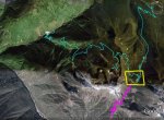
You went wrongnear point 179, 14:17:30 o'clock; or a few minutes/points later. You should have kept heading south and up. I looked in Google earth but there is a poor image overlap (very blurred) at the crucial area.
The yellow box is where the error happened. The pink line is the yery rough approximate route.
imported post
You went wrongnear point 179, 14:17:30 o'clock; or a few minutes/points later. You should have kept heading south and up. I looked in Google earth but there is a poor image overlap (very blurred) at the crucial area.
The yellow box is where the error happened. The pink line is the yery rough approximate route.
Attachments
Hill Climber
New member
imported post
imported post
aebbern wrote:
Here's a track I made earlier this summer of the area. The waypoint labelled "saddle" is where you drop over the west side, down a series of switchbacks and you come out at Cody (just above Sandon). If you view it in Google Earth, you can just barelysee the switchbacks. My first time uploading a track so hope it works.
Cheers, Hill Climber
imported post
aebbern wrote:
We tried last weekend to do the Retallack-Cody route. Obviously got screwed up somewhere coming from the Retallack side (GPS track attached) but we managed to find a nice trail heading over by Dardanelles Creek. Sure would like to know where we made the wrong turn.
Here's a track I made earlier this summer of the area. The waypoint labelled "saddle" is where you drop over the west side, down a series of switchbacks and you come out at Cody (just above Sandon). If you view it in Google Earth, you can just barelysee the switchbacks. My first time uploading a track so hope it works.
Cheers, Hill Climber
Attachments
imported post
imported post
If you look closely at the map online that you posted vs your track, the road over to Cody comes off where you leave Stenson Creek 50°0'3.7" 117°9'48.8". Alternately, if you look at air photos, it looks like once you make that loopback out of Stenson Creek, just above tree line, there are a bunch of trails to the west, your path took you north. From the air photos, it also looks like there is an alternate route the continues up Stenson Creek and comes over the ridge to the west after the headwaters. Cheers.
Edit: Looks like Hillclimber has the track for you, just ignore me...
imported post
If you look closely at the map online that you posted vs your track, the road over to Cody comes off where you leave Stenson Creek 50°0'3.7" 117°9'48.8". Alternately, if you look at air photos, it looks like once you make that loopback out of Stenson Creek, just above tree line, there are a bunch of trails to the west, your path took you north. From the air photos, it also looks like there is an alternate route the continues up Stenson Creek and comes over the ridge to the west after the headwaters. Cheers.
Edit: Looks like Hillclimber has the track for you, just ignore me...
imported post
imported post
Our trip report is here:
http://adsmc.informe.com/forum/ride-reports-post-your-pic-s-here-f9/chucker-s-kootenay-ride-t922.html
Will be back next season to do the Reco Mtn route the right way.
imported post
Our trip report is here:
http://adsmc.informe.com/forum/ride-reports-post-your-pic-s-here-f9/chucker-s-kootenay-ride-t922.html
Will be back next season to do the Reco Mtn route the right way.
imported post
imported post
Hey
I saw your group in Kaslo....
Just looking at your photos....the ride after the wrong turnit looks WAY more fun than the road down into sandon.
Give me a pm next time u are going to do the ride again. I have a few other routes on the ride....will not post them here.
U can ride almost all dirt from Balfour to Sandon.....A few short hwy sections.
KTM!!!!!
imported post
Hey
I saw your group in Kaslo....
Just looking at your photos....the ride after the wrong turnit looks WAY more fun than the road down into sandon.
Give me a pm next time u are going to do the ride again. I have a few other routes on the ride....will not post them here.
U can ride almost all dirt from Balfour to Sandon.....A few short hwy sections.
KTM!!!!!
imported post
imported post
shoobear wrote:
Cheers,
Andy
imported post
shoobear wrote:
Hi Shoobear... I'll for sure ping you before our next ride in that area. I'd love to learn how to get from Balfour to Sandon with minimal pavement. It would be great if you could joins us for the riding (although our group seems pretty KTM-heavy already... need more Husky's out thereGive me a pm next time u are going to do the ride again. I have a few other routes on the ride....will not post them here.
U can ride almost all dirt from Balfour to Sandon.....A few short hwy sections.
KTM!!!!!
Cheers,
Andy
Shoobear, Hill Climber and Stefan showed 12 of us around Kaslo last weekend... and here we are at the saddle of Reco Mountain:

Thanks Shawn, Chuck & Stefan for showing us those great trails near Kaslo... you guys are incredibly lucky to have that area as your backyard.
Cheers,
Andy
Thanks Shawn, Chuck & Stefan for showing us those great trails near Kaslo... you guys are incredibly lucky to have that area as your backyard.
Cheers,
Andy
It's not really a ride report, but some good (and not so good...) pictures over here. Things got a bit carried away on our last night in Castlegar... some of us didn't remember much of it
http://adsmc.informe.com/forum/ride-reports-post-your-pic-s-here-f9/hot-springs-2011-t1484.html
http://adsmc.informe.com/forum/ride-reports-post-your-pic-s-here-f9/hot-springs-2011-t1484.html