Flatlander help planning for Kootenays, etc

Hi there - new to the forum - residing in Manitoba. Find myself with time on my hands suddenly, want to do a trip about 10 days. Figured a counterclockwise loop starting in Southeast BC, across as far as OK valley, then north and back towards Calgary. Something like below which is a rough plan, ready to deviate and adjust as needed.

Question, am I just too early to be able to do some FSRs? I wanted to do Gray Creek, but realized now, that's not on till July sometime :)

So, any advice in regards to conditions along any of the rough route I have below for portions you are familiar with. What is open? Specific recommendations? General advice or opinions?

Traveling on KTM950. Do lots of gravel riding and some trails with that bike. Also, spend time riding motorcycle trials when I can.

Thanks in advance!
Bernhard
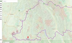

West22_2.jpg
 

Fatherwes

New member
I’m interested in the Gray Creek pass too. I am hoping to go through there within the next two weeks. Has anybody been through there recently? Is it clear? I’m guessing the road should be bare by now with maybe some snow on the ground?

I just discovered this website. It seems to have some great info, especially for FSR’s near the coast. It doesn’t offer current status for Gray-Redding Creek…
https://backcountrybc.ca/trails-dat...planning-maps/forest-service-road-dynamic-map
 

NW Coaster

New member
I think you mean clockwise, no?
Gray Creek Store usually posts info about the pass opening but I think you're a little early if you're travelling soon.
To add some gravel to your mostly pavement ride, you could check out the Columbia & Western rail trail near Castlegar. You can also cut across from just west of Grand Forks (Gibbs Creek Rd.)to Greenwood, passing through what used to be the town of Phoenix (read up on that). When you're doing the Nickel Plate road at Hedley, look or ask directions for the French mine if you like caves. Your route from Penticton to Lumby gets up above 4,500 ft in places so you may find snow. It will surely be a little slimy. North of Lumby just before the #1 highway look for Frog Falls Prov. park. Find the way up to the top, the falls should be roaring this time of year.
It would be nice if you could avoid all that Trans Canada Highway and construction after Revelstoke. Why not go south to the Shelter Bay ferry (free) and on to New Denver. Just east of there is the old ghost town of Sandon (read up on that). Then, just past Sandon is another ghost town, Cody and from there you can (snow permitting) go up and over Reco Mountain and come out on the highway at Retallack. Head east and hit Buchanan Lookout near Kaslo, head south and check out Toad Rock Motorcycle Campground, Take the ferry from Balfour across to Gray Creek and if you can't do the pass, the road to Creston is beautiful. Find your way east from there.
I expect a lot of the high points will be in snow, unfortunately but it should still be a good trip.
 
Excellent, thank you NW Coaster. I'm hoping to head out as soon as I can get sorted (within a week I hope). I'd had Sandon recommended (Power Generating Station) also from another. I definitely wanted to avoid any of the major routes as much as is possible. Cody-Retallack climbs over 2200m so that's definitely out from what I'm hearing for snow cover. Good tip on the Gibbs Creek road, my backroads and Gaia maps all don't have the first piece of it, but google maps did! Lots of good tips, thank you! I'm since hearing there's more snow lower than typical this time of year right now, so perhaps I have to adjust (just happens I have time right now suddenly).
 

Fatherwes

New member
I can vouch for the Columbia & Western rail-to-trail route from Castlegar to Christina Lake. Terrific piece of track. Beware that it’s a shared use trail. Expect cars & trucks, other bikes, families (with little kids) on bicycles or walking and even the odd side by side or quad coming at you sideways in a corner. But stunning views and good surface. Highlights include the kilometre long tunnel.
 

NW Coaster

New member
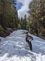
Ya, I think most of my recommendations are probably going to be in snow. Even Phoenix, I forgot, is 4,600 ft. Would be better if you could wait a month. And yes, it’s been cooler and wetter this year so summer is arriving a little late.
 

Fatherwes

New member
i just spoke with the Gray Creek Store. The Gray-Redding Creek Pass (Kootenay Lake to Kimberley) is NOT open.
I was through there last fall but didn’t realize it was that high (6800ft).
 
i just spoke with the Gray Creek Store. The Gray-Redding Creek Pass (Kootenay Lake to Kimberley) is NOT open.
I was through there last fall but didn’t realize it was that high (6800ft).
Ha, your trip to out east takes you pretty close by me (Russell, MB). If you want to divert and need a place to stay, let me know.
 
So, based on what I'm learning, etc. I'm going to try to go in a month, putting it to beg of July instead. Hopefully better weather and more passes open then. And give me more time to refine my route.
 

Fatherwes

New member
If you want to ride the higher trails, it looks like July will be better. I would expect things to start opening up very soon, but summer is slow coming this year. The good news is you should still be early enough to miss the fire season!

You’re right, I’ll be passing pretty close to Russell! You might hear from me!
Same for you, you’ll be close to Salmon Arm on your trip. Let me know when you’re in the area. If I’m back from my trip, hopefully we can meet up - and reciprocate!
 

Derbyl

New member
I have tried Grey creek in June and there was still snow. Also, we have 130% snow coverage this year in the East Kootenays (average is 100%) so still lots at high elevation. I am planning a ride through Grey creek, KVR (Kettle valley railway) as much as possible, which so far takes me on it from Castlegar to Christina Lake, Hwy 3 to Grand forks (non-motorized only), back on the KVR until somewhere near Hwy. 33 south of Kelowna, Then south on FSR's to Penticton, north to Summerland then west to Princeton. I'll take various roads through Coalmont, Tulameen, Douglas Lake ending in Westwold on Hwy 97 east of Kamloops. From there I'd choose to go to Vernon, east on Hwy 6 to Nakusp, Hwy 6 to New Denver (great place for lunch there), Hwy 31A to Kaslo and then continue south to the ferry back to Crawford bay and Grey Creek to home in Invermere.
 

Phile

New member
Hi there trialsntribulation, I see your route has a section along the Pend Oreille River it's a 40km section and it is spectacular.
 

Attachments

  • IMG_3001.jpg
    IMG_3001.jpg
    796.6 KB · Views: 5
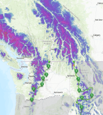
I use the snow coverage map on the BDR site. It is pretty accurate from what I have discovered by visiting some of the areas...
This is what it looks like today. Go here and click the little snowflake in the top right corner and click "snow coverage" https://ridebdr.maps.arcgis.com/apps/webappviewer/index.html?id=c7e559fa199d448485a6e2e1e45e0f3d
View attachment 385923

View attachment 385925
Cool. Great link! Lots of snow still, hopefully in 3 or so weeks it looks a bit better
 
Top