
-
Visit DualSportBC Facebook group with over 10 000 active members: https://www.facebook.com/groups/dualsportbc
- Home
- Forums
- Forum
- HISTORICAL DOCUMENTS (The Archives)
- Regional Area Forums of BC CLOSED
- The Kootenay / Boundary Region
- Kootenay DSBC Riders Section
You are using an out of date browser. It may not display this or other websites correctly.
You should upgrade or use an alternative browser.
You should upgrade or use an alternative browser.

Sparkle
New member
imported post
imported post
Hi aebbern:
A few posts ago koots_roots wrote about going up the"short-cut" from the WEST (Gray Creek) side:
"while i was unloading the bike, a guy stopped to inform me that bridge a few kms (~3) up this spur will be yanked tomorrow AM. not sure if you can bypass this by riding right under the powerlines. he did say there will likely be some quad/bike friendly route openned up just north of this bridge."
When I was over last week I asked about this at the store and was told they are removing the bridgenear the lower end ofthe WEST side of the power-line short-cut toeliminate maintainance, but they planned toleave a prepared place for traffic to ford thestream. Maybe that's what they were refering to.
There was lots of equipment and work being done, but the guys were friendly andquick to make a path...especially for a bike which doesn't take much.This road is getting some heavy use, and I'm sure it's a PITA for the crews, so maybe they are just trying to discourage traffic as much as they can.
There are no bridges on the short-cut on the EAST side (Redding Creek ). So if just getting to thetop is what you want, you should be okay. Getting down the WEST side to the main road?........I'm not so sure.
On my rideon Sat. Sept 12, all the bridges on the main road where in perfect shape and theshort-cut access point on the east side was clear, dry and normal.
Sparkle
imported post
Hi aebbern:
A few posts ago koots_roots wrote about going up the"short-cut" from the WEST (Gray Creek) side:
"while i was unloading the bike, a guy stopped to inform me that bridge a few kms (~3) up this spur will be yanked tomorrow AM. not sure if you can bypass this by riding right under the powerlines. he did say there will likely be some quad/bike friendly route openned up just north of this bridge."
When I was over last week I asked about this at the store and was told they are removing the bridgenear the lower end ofthe WEST side of the power-line short-cut toeliminate maintainance, but they planned toleave a prepared place for traffic to ford thestream. Maybe that's what they were refering to.
There was lots of equipment and work being done, but the guys were friendly andquick to make a path...especially for a bike which doesn't take much.This road is getting some heavy use, and I'm sure it's a PITA for the crews, so maybe they are just trying to discourage traffic as much as they can.
There are no bridges on the short-cut on the EAST side (Redding Creek ). So if just getting to thetop is what you want, you should be okay. Getting down the WEST side to the main road?........I'm not so sure.
On my rideon Sat. Sept 12, all the bridges on the main road where in perfect shape and theshort-cut access point on the east side was clear, dry and normal.
Sparkle
S
samac
Guest
imported post
imported post
Looky Looky here.
A newbie is the first to post in this section for the calender year 2010. I have read every thread on this Grey CreekPass and I am excited to get out and try this new hobby sport.
Any advice from you old pros on how to properly prepare. Obvious things already considered such as fuel, GPS, and the usual Back Country prepardness kit.
Where can I find good quality mapping for the area. Is this pass clearly marked fromEast to West and vis versa? Google maps is decent but im sure there is something better.
Ride on...........:hb:
imported post
Looky Looky here.
A newbie is the first to post in this section for the calender year 2010. I have read every thread on this Grey CreekPass and I am excited to get out and try this new hobby sport.
Any advice from you old pros on how to properly prepare. Obvious things already considered such as fuel, GPS, and the usual Back Country prepardness kit.
Where can I find good quality mapping for the area. Is this pass clearly marked fromEast to West and vis versa? Google maps is decent but im sure there is something better.
Ride on...........:hb:
Sparkle
New member
imported post
imported post
Hi samac:
Welcome to the group.
Normal years the snow-slides don't melt until the end of June, and then usually some time to clear the snow-slide debris, so you have lots of time to prepare. Although this year might be sooner.
Many years ago this ride was a serious undertaking, but these days it's a pretty mild event.....still beautiful and satisfying as ever though.
Thereare signs here and there but basically you just follow the most improved road, and you won't go wrong. Last time I tested my posted GPX file and it is accurate to within a few feet. Opening that same file in Google Earth and zooming-in shows it better than a map.
http://www.dualsportbc.com/forums/view_topic.php?id=7693&forum_id=56
If your bike will go 100km on a tank you'll get there with some to spare. Gas places are Crawford Bay and Lake Shore store on the west side, and Marysville on the east side.
As far as gear is concerned....if you have your tire-pump and patch kit, and your credit card, you'll probably be okay. Post when you plan on going,you mightfind some company for this ride.
Sparkle
imported post
Hi samac:
Welcome to the group.
Normal years the snow-slides don't melt until the end of June, and then usually some time to clear the snow-slide debris, so you have lots of time to prepare. Although this year might be sooner.
Many years ago this ride was a serious undertaking, but these days it's a pretty mild event.....still beautiful and satisfying as ever though.
Thereare signs here and there but basically you just follow the most improved road, and you won't go wrong. Last time I tested my posted GPX file and it is accurate to within a few feet. Opening that same file in Google Earth and zooming-in shows it better than a map.
http://www.dualsportbc.com/forums/view_topic.php?id=7693&forum_id=56
If your bike will go 100km on a tank you'll get there with some to spare. Gas places are Crawford Bay and Lake Shore store on the west side, and Marysville on the east side.
As far as gear is concerned....if you have your tire-pump and patch kit, and your credit card, you'll probably be okay. Post when you plan on going,you mightfind some company for this ride.
Sparkle
S
samac
Guest
anyone been accross yet. Going to be in the area July 4th

UnbForester05
New member
Ran into a fella on a KLR that tried the pass a couple of weeks ago. Said he just about made the summit and hit snow. Not sure if it will yet be clear..

Ahhhh man!........I hate it when that happens....
thanks for the report dd...
Sparkle
It was great I just had to extend my ride a few hours on a sunny day, got to Castlegar and most of the work was done
 .

DualSport855
New member
Grey Creek Pass open!!
Grey Creek Pass open!!
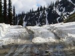
Came through (eastbound) last night (Sunday June 27 2010) at 17:00 this is what the summit looked like after a couple of good days of melting. Pretty easy to push through those ruts on my KLR with a set of TKC80's


Grey Creek Pass open!!
Came through (eastbound) last night (Sunday June 27 2010) at 17:00 this is what the summit looked like after a couple of good days of melting. Pretty easy to push through those ruts on my KLR with a set of TKC80's


Attachments
Last edited: