Free topo maps for Canada

joker650

Active member
imported post

imported post

Just loaded it on the comp. Looks prety good...shows more bush roads than Mapsource :tup:
 

PaulBurke

New member
imported post

imported post

ktmken wrote:
PaulBurke wrote:
Downloaded and installed on my gps just fine. Awesome!
Zumo?
I picked up a Zumo 550 with the XM antenna.

Here's some pics. I haven't mounted the big tank back on it yet, nor have I put the 908RRs on. I'm drowning in tax accounting bs right now.
COOLKTM_6.jpg

My über kül cooler/Led brake light turnsignal housing.

COOLKTM_5.jpg


And lookie what's inside. The remote XM radio/weather/traffic antenna thingamajig.

COOLKTM_1.jpg


The mount is cool, you don't need to unplug any cables to remove it from your bike
thumb.gif


COOLKTM_4.jpg


Only thing "cooler"
lol8.gif
is a custom made splash screen for the Zumo.
COOLKTM_3.jpg
 

PaulBurke

New member
imported post

imported post

Yeah, the roads in the mountains around my place are all shown there. Looks really good. I'm going try finding some of the roads. Fun fun.
 

ktmken

New member
imported post

imported post

wow.... nice.... I have had a zumo since July and I love it.

Nice bike BTW

KTMKen
 

joker650

Active member
imported post

imported post

Ahh....nice to se a man not afraid to flex his own inner designer.;)U gunna have everyone in BAJA hittin u up for a cold cervesa.

Nice ZUMO !


COOLKTM_5.jpg
 
I

ibycus

Guest
imported post

imported post

PaulBurke wrote:
Downloaded and installed on my gps just fine. Awesome!


Good to hear. At least I know I didn't do anything silly when building the Mac version. (now I just have to make sure I keep it up to date along with the PC version!).

Dale


**edit... never mind, thought this was a reply in another forum. Hadn't realized I hadn't announced the release of the Mac version here. That was over in the ADVRider forum.
 
I

ibycus

Guest
imported post

imported post

I'm currently working on see if I can get routing to work (nothing available yet), and I'm looking for some feedback.

I'm making some good progress, but there are some definite problems which are going to be difficult, if not impossible for me to overcome.

1. It is questionable whether I'll ever be able to get it to route successfully in Mapsource (although routing on the GPS is likely still an option).
2. The routes generated are rarely 'right' they will frequently direct you the wrong way down one way streets etc. For example, on a 'test route' from my house to the University of Calgary, every turn is wrong, directing you to drive on the wrong side of the road, take turns off of overpasses, and go down the on ramp rather than the off ramp, but it does tell you to drive on the right roads.
3. Road names and addressing still won't be present. Have to wait for the data to be made available at geobase (or elsewhere) to get this to work.


How useful would autorouting be in the above context?
 
D

dooveman

Guest
imported post

imported post

I don't think auto routing is importantat all. Especially on the trails. I have a couple of maps loaded on my garmin so if I need to auto route I can switch to that map. But on the trails, autorouting is just :shoot:.
 

Dorky

Moderator
imported post

imported post

dooveman wrote:
But on the trails, autorouting is just :shoot:.

I would agree. The autorouting never makes any sense on the back roads. I think it is far more important to have the road names included on the maps.
 
I

ibycus

Guest
imported post

imported post

Road names have to wait until I can get the data for road names. Its supposed to be released some time soon, but governments always move at a snail's pace.
 
I

ibycus

Guest
imported post

imported post

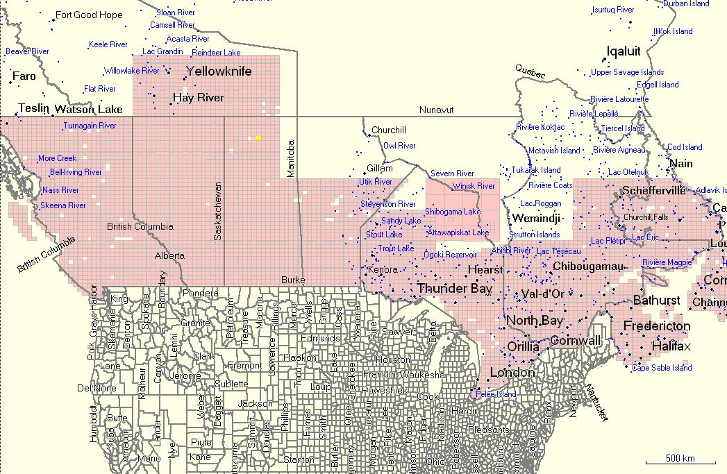
Thought I'd post the coverage map for the next version, so you know what to look forward to. I'm in the process of filling in holes right now. I'll be compiling/uploading a new version when this is done (probably in a couple of days)

coverage.jpg
 
D

dooveman

Guest
imported post

imported post

Now come on, really! How am I supposed to cover all that on my KLR! ;)
 
W

woodypecker

Guest
imported post

imported post

awesome. cant wait for new app. thanx
 
W

woodypecker

Guest
imported post

imported post

right on thanx.i just happened across this forum during a google search. i guess i will need a 2 gig card for my garmin 250w. Or will it fit on a 1 gig?
 
I

ibycus

Guest
imported post

imported post

You probably can't load the whole country at the same time, regardless of the size of the card you're using (Garmin has a limit to the number of segments you can load at one time, I think its 2025 segments which is less than a gig.).

Dale
 
W

woodypecker

Guest
imported post

imported post

cool. all i want is bc and alberta. so i can just load those provinces then? Cant wait til my sd card comes. I will download when i get home tonight. thanx i cant wait to see your map.
 
W

woodypecker

Guest
imported post

imported post

i live on vancouver island so that is what i am most interested in for off roads to different lakes.
 
Top