imported post
imported post
Hi Guys:
I thought I should share some input I received from an observer who was a surveyor by profession:
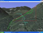
"I've been following the northwest-connector saga. You're idea of checking out the valleyside is a good one. My contour sheet shows this is very steep terrain (85% grade). The section that goes straight down that 6fiddy says looks like a river bed is actually a landslide that starts at the top landing all the way to the bottom. What looks like an access road at the bottom is actually the creek bed, and there's no road there. The haul-roads are 1/2 way up the sides of the valley, on either side. They look long....and overgrown.From your current route, (Franhosers track)turningright at the brow of the valley, up the valley gets you closer to the skidder trails, but they are on extremely steep ground, and it's a very long way down the valley to the main road and you have to cross the slide. Anyway, like you suggest, actually flaggingout a viable route might save a lot of sweat."
I look forward to hearing from North and company from their exploration. I still think the best route is over to the Statlu landing where we have a confirmed road down to Statlu Main. It will call for cleaning up one of the spur roads through the clearcut heading south but it maybe the least work to connect.
Here is a picture sent along with the above comments:
otg